Aquatic Club Inc
Create the Future”
About the Myall Lakes
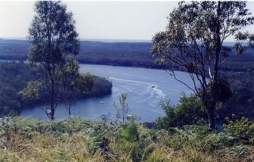
The Myall Lakes comprises 10,000 hectares of coastal brackish waterways, located within the Myall Lakes National Park, which are approx 44,000 hectares of natural bushland. The waterway is made up of 3 major lakes, the Myall Lake, the Boolambayte Lake and the Broadwater. The 3 lakes are connected by the narrows and are all fully navigable. The lake system is recognised internationally with the National Park being listed as a RAMSAR Wetland.
The Water depth over the lake system averages 2 to 3 metres and most areas are fully navigable. The eastern shoreline is primarily sand bottom, providing good anchorage. There are 25 public courtesy moorings situated throughout the lakes, located at Nerong, Bombah Point, Professors Cove, Nosworthys, Violet Hill, Long Point Bay and Kataway Bay. The moorings are free, except for the commercial moorings located at Bombah Point.
A mobile sewage barge funded by the maritime arm of Roads and Maritime Services of NSW, operates on the lake system to dispose of boat's effluent and is free to private boat owners. A wharf-based sewage pump out facility is located at Bombah Point and is also free.
Launching ramps are provided at Violet Hill, Mungo Brush and Nerong Village. Wharves are located at Violet Hill, Korsman’s Landing, Bombah Point and there are 3 wharves located in the lower Myall River at Tamboi, Engel’s Reach and Kangaroo Island Information Wharf.
Read More About the Myall Lakes
Further Information can also be found on the:
Myall Lakes National Park Home Page
Myall Lakes National Park Environment Page